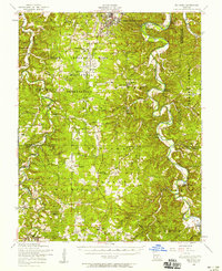
1954 Map of Big Piney
USGS Topo · Published 1958About this map
Fort Leonard Wood Military Reservation dominates the northern landscape of this mid-1950s survey, illustrating the significant federal footprint in the Ozarks following World War II. The map captures a region in transition, where established rural communities like Bloodland and Big Piney sit adjacent to military training grounds and the sprawling Mark Twain National Forest. The winding path of the Big Piney River and Roubidoux Creek dictates the local geography, creating a maze of steep hollows such as Musgrave Hollow and Watts Hollow.
Find a feature on this map
75 named features on this map. Tap any name to fly to it.
Don’t see what you’re looking for? This feature index may not catch every label — zoom into the map to look around manually.
Map Details
Editions of this 1954 Big Piney Map
3 editions found
Other maps of this area

1912 · Rolla
USGS Topo · 1:62,500

1931 · Manes
USGS Topo · 1:48,000

1936 · Waynesville
USGS Topo · 1:48,000

1937 · Edgar Springs
USGS Topo · 1:48,000

1941 · Big Piney
USGS Topo · 1:62,500

1941 · Manes
USGS Topo · 1:62,500

1941 · Bado
USGS Topo · 1:62,500

1942 · Waynesville
USGS Topo · 1:62,500

1943 · Richland
USGS Topo · 1:62,500

1943 · Big Piney
USGS Topo · 1:62,500