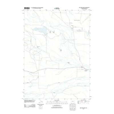
2012 Map of Big Piney West
USGS Topo · Published 2012About this map
Plainview Cem serves as a quiet landmark in this high-desert landscape, located just north of the meandering S Piney Cr. The area is defined by a series of parallel watercourses including N Piney Cr, Middle Piney Cr, and N Channel Middle Piney Cr, which cut through the sagebrush-rich terrain of western Wyoming. Resource extraction and cattle ranching shape the local economy, evidenced by the East Star Corral Oil Field and various reservoirs such as Sixty-Seven Reservoir. Local family names are etched into the geography through features like D B Budd Butte and McNinch Wash, alongside numerous local roads like Bill Budd Rd and Mickelson Ln. These labels reflect a history of settlement tied closely to the available water and the sparse, open range land west of Big Piney.
Find a feature on this map
33 named features on this map. Tap any name to fly to it.
Don’t see what you’re looking for? This feature index may not catch every label — zoom into the map to look around manually.
Map Details
Editions of this 2012 Big Piney West Map
This is the sole edition of this map. No revisions or reprints were ever made.
Other maps of this area

1939 · Big Piney
USGS Topo · 1:125,000

1942 · Big Piney
USGS Topo · 1:125,000

1955 · Preston
USGS Topo · 1:250,000

1958 · Preston
USGS Topo · 1:250,000

1962 · Preston
USGS Topo · 1:250,000

1969 · Chimney Butte
USGS Topo · 1:24,000
1969 · Milleson Draw
USGS Topo · 1:24,000

1969 · Cretaceous Mountain
USGS Topo · 1:24,000
1970 · Budd Reservoir
USGS Topo · 1:24,000
1970 · Big Piney West
USGS Topo · 1:24,000