
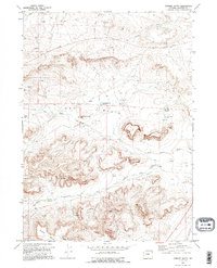
1969 Map of Chimney Butte
USGS Topo · Published 1973About this map
The Big Piney Oil Field dominates this landscape in Sublette County, revealing a mid-century industrial network of pipelines, gas wells, and drill holes. The terrain transitions from the high ground of Little Mesa and Chimney Butte down into the arid expanses of the Dry Basin. Water management is central to the area's utility, evidenced by infrastructure like the Chimney Butte Reservoir, Flat Top Reservoir, and the irrigation-focused Yankee Ditch and Green River Island Ditch.
Find a feature on this map
22 named features on this map. Tap any name to fly to it.
Don’t see what you’re looking for? This feature index may not catch every label — zoom into the map to look around manually.
Map Details
Editions of this 1969 Chimney Butte Map
2 editions found
Other maps of this area

1939 · Big Piney
USGS Topo · 1:125,000

1942 · Big Piney
USGS Topo · 1:125,000

1955 · Preston
USGS Topo · 1:250,000

1958 · Preston
USGS Topo · 1:250,000

1962 · Preston
USGS Topo · 1:250,000

1969 · La Barge
USGS Topo · 1:24,000
1969 · Milleson Draw
USGS Topo · 1:24,000

1969 · Cretaceous Mountain
USGS Topo · 1:24,000
1969 · The Hogsback
USGS Topo · 1:24,000
1969 · La Barge SE
USGS Topo · 1:24,000