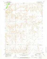
1969 Map of La Barge SE
USGS Topo · Published 1973About this map
Green River flows through the northwest corner of this Wyoming landscape, defining a riparian corridor that includes Long Island and the drainage of Cowdell Waste Water. The surrounding terrain is heavily dissected by deep drainages such as Figure Four Canyon, Bird Canyon, and Steed Canyon. As of the late 1960s, the area reflects a landscape transitional between ranching and resource extraction, marked by numerous drill holes and oil wells scattered throughout the high ground. The map also records the jurisdictional intersection of Sublette, Lincoln, and Sweetwater counties, with travel defined by the County Line Road and a network of jeep trails and unimproved roads like Steed Road. This document provides a record of land use and topography in the Green River Basin before later 20th-century developments modified the access and infrastructure.
Find a feature on this map
14 named features on this map. Tap any name to fly to it.
Don’t see what you’re looking for? This feature index may not catch every label — zoom into the map to look around manually.
Map Details
Editions of this 1969 La Barge SE Map
2 editions found
Other maps of this area

1955 · Preston
USGS Topo · 1:250,000

1955 · Lander
USGS Topo · 1:250,000

1958 · Lander
USGS Topo · 1:250,000

1958 · Preston
USGS Topo · 1:250,000

1961 · Lander
USGS Topo · 1:250,000

1962 · Preston
USGS Topo · 1:250,000

1968 · Anderson Canyon
USGS Topo · 1:24,000

1968 · Names Hill
USGS Topo · 1:24,000
1968 · Monument Butte
USGS Topo · 1:24,000

1969 · Oasis Well
USGS Topo · 1:24,000