
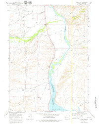
1968 Map of Names Hill
USGS Topo · Published 1971About this map
Names Hill rises as a prominent landmark in the Wyoming landscape, marking a crucial junction for westward travelers following the Emigrant Trail. This 1968 field-checked survey reveals the layered history of the Green River valley, where the historic Sublet Cutoff (Emigrant Trail) diverted pioneers toward drier routes. Near the river's edge, a Historical Monument commemorates the names carved into the soft limestone cliffs by migrants passing through in the 19th century.
Find a feature on this map
24 named features on this map. Tap any name to fly to it.
Don’t see what you’re looking for? This feature index may not catch every label — zoom into the map to look around manually.
Map Details
Editions of this 1968 Names Hill Map
2 editions found
Other maps of this area

1945 · Fort Hill
USGS Topo · 1:62,500

1947 · Fort Hill
USGS Topo · 1:62,500

1955 · Preston
USGS Topo · 1:250,000

1958 · Preston
USGS Topo · 1:250,000

1962 · Preston
USGS Topo · 1:250,000

1968 · Anderson Canyon
USGS Topo · 1:24,000

1968 · Fontenelle Reservoir SE
USGS Topo · 1:24,000

1968 · Fontenelle Reservoir SW
USGS Topo · 1:24,000

1969 · La Barge
USGS Topo · 1:24,000
1969 · The Hogsback
USGS Topo · 1:24,000