
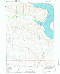
1968 Map of Fontenelle Reservoir SW
USGS Topo · Published 1971About this map
Emigrant Trail and the Sublette Cutoff cross this landscape, marking the historic path of westward expansion through Lincoln County. The map captures a moment of transition where deep historical roots meet modern infrastructure, notably where the Fontenelle Reservoir was recently established along the Green River. Along the western bluffs, the Holden Cem remains as a silent marker of early settlers near Holden Hill. Drainage patterns like Fontenelle Creek and Pomeroy Draw define the terrain, while the inclusion of numerous pipelines and several gravel pits points to the area's mid-century industrial utility. Underwater contours provided by the U. S. Bureau of Reclamation offer a rare look at the original riverbed submerged beneath the reservoir's normal pool elevation.
Find a feature on this map
21 named features on this map. Tap any name to fly to it.
Don’t see what you’re looking for? This feature index may not catch every label — zoom into the map to look around manually.
Map Details
Editions of this 1968 Fontenelle Reservoir SW Map
2 editions found
Other maps of this area

1945 · Fort Hill
USGS Topo · 1:62,500

1947 · Fort Hill
USGS Topo · 1:62,500

1954 · Ogden
USGS Topo · 1:250,000

1955 · Preston
USGS Topo · 1:250,000

1958 · Ogden
USGS Topo · 1:250,000

1958 · Preston
USGS Topo · 1:250,000

1960 · Ogden
USGS Topo · 1:250,000

1962 · Preston
USGS Topo · 1:250,000

1968 · Anderson Canyon
USGS Topo · 1:24,000

1968 · Fontenelle Reservoir SE
USGS Topo · 1:24,000