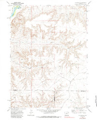
1969 Map of La Barge SE
USGS Topo · Published 1984About this map
The Green River flows through the northwestern corner of this landscape, its path punctuated by Long Island and the drainage of Cowdell Waste Water. This 1969 survey captures a rugged section of Wyoming where the high-desert plateau is deeply etched by a network of drainage systems, most notably the winding reaches of Figure Four Canyon and Bird Canyon. The map records a significant concentration of resource extraction markers, with numerous Drill Holes and Oil Wells scattered across the terrain, indicating the mid-century industrial activity in this part of the state.
Find a feature on this map
11 named features on this map. Tap any name to fly to it.
Don’t see what you’re looking for? This feature index may not catch every label — zoom into the map to look around manually.
Map Details
Editions of this 1969 La Barge SE Map
2 editions found
Other maps of this area

1955 · Preston
USGS Topo · 1:250,000

1955 · Lander
USGS Topo · 1:250,000

1958 · Lander
USGS Topo · 1:250,000

1958 · Preston
USGS Topo · 1:250,000

1961 · Lander
USGS Topo · 1:250,000

1962 · Preston
USGS Topo · 1:250,000

1968 · Anderson Canyon
USGS Topo · 1:24,000

1968 · Names Hill
USGS Topo · 1:24,000
1968 · Monument Butte
USGS Topo · 1:24,000

1969 · Oasis Well
USGS Topo · 1:24,000