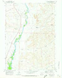
1969 Map of Milleson Draw
USGS Topo · Published 1973About this map
The Green River flows through a landscape defined by ranching and early water management in this 1969 survey of Sublette County. Large fluvial features like Tarters Island and Long Island split the river's path, while a network of irrigation systems including the Highline Canal, O'Neil Ditch, and Midmermac Ditch demonstrate the effort required to hydrate the high plains. The terrain is marked by prominent ridges such as Castle Rock Hill and Red Hill, which overlook a series of dry draws and seasonal catchments like Jackrabbit Reservoir.
Find a feature on this map
30 named features on this map. Tap any name to fly to it.
Don’t see what you’re looking for? This feature index may not catch every label — zoom into the map to look around manually.
Map Details
Editions of this 1969 Milleson Draw Map
This is the sole edition of this map. No revisions or reprints were ever made.
Other maps of this area

1939 · Big Piney
USGS Topo · 1:125,000

1942 · Big Piney
USGS Topo · 1:125,000

1955 · Preston
USGS Topo · 1:250,000

1955 · Lander
USGS Topo · 1:250,000

1958 · Lander
USGS Topo · 1:250,000

1958 · Preston
USGS Topo · 1:250,000

1961 · Lander
USGS Topo · 1:250,000

1962 · Preston
USGS Topo · 1:250,000

1964 · Ross Butte
USGS Topo · 1:24,000

1969 · Oasis Well
USGS Topo · 1:24,000