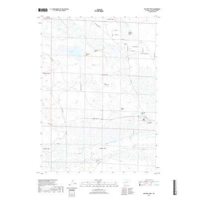
2017 Map of Big Piney West
USGS Topo · Published 2017About this map
Big Piney serves as the focal point for this high-desert landscape in Sublette County, where the sprawling drainage networks of the Green River Basin define the local topography. The map illustrates a complex hydraulic environment dominated by North Piney Cr, Middle Piney Cr, and South Piney Cr, which meander through a series of wide draws and swales. The presence of Sixty-Seven Reservoir and landforms like D B Budd Butte and Sixty-Seven Butte highlight the ranching heritage of the region, where water management is critical to the local economy. Genealogists will find the Plainview Cem south of the main settlement particularly noteworthy. The grid of rural roads, including Middle Piney Rd and Star Corral Rd, provides a clear view of the modern land divisions and access routes within these historic townships.
Find a feature on this map
42 named features on this map. Tap any name to fly to it.
Don’t see what you’re looking for? This feature index may not catch every label — zoom into the map to look around manually.
Map Details
Editions of this 2017 Big Piney West Map
This is the sole edition of this map. No revisions or reprints were ever made.
Other maps of this area

1939 · Big Piney
USGS Topo · 1:125,000

1942 · Big Piney
USGS Topo · 1:125,000

1955 · Preston
USGS Topo · 1:250,000

1958 · Preston
USGS Topo · 1:250,000

1962 · Preston
USGS Topo · 1:250,000

1969 · Chimney Butte
USGS Topo · 1:24,000
1969 · Milleson Draw
USGS Topo · 1:24,000

1969 · Cretaceous Mountain
USGS Topo · 1:24,000
1970 · Budd Reservoir
USGS Topo · 1:24,000
1970 · Big Piney West
USGS Topo · 1:24,000