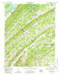
1952 Map of Big Ridge Park
USGS Topo · Published 1979About this map
Big Ridge State Park and the sprawling waters of Norris Lake define this mid-century landscape where the ridges of East Tennessee meet the Tennessee Valley Authority’s hydrologic engineering. The map documents the displacement and resettlement of the era, showing Loyston near the reservoir boundary alongside the newly established New Loyston. The rugged topography is organized by parallel heights including Hickory Pine Ridge and Chestnut Ridge, creating isolated valleys where local life centered on small institutions like Central View School and Byrams Fork Church. Genealogists will find a high density of family burial grounds, such as Shodderly Cemetery and Warwick Cemetery, which often remain as the only physical markers of families who lived here before the valleys were flooded or the park was established. The presence of Stokes Mill on Bullrun Creek reflects a rural economy still tied to local watercourses.
Find a feature on this map
98 named features on this map. Tap any name to fly to it.
Don’t see what you’re looking for? This feature index may not catch every label — zoom into the map to look around manually.
Map Details
Editions of this 1952 Big Ridge Park Map
3 editions found
Other maps of this area

1893 · Briceville
USGS Topo · 1:125,000

1895 · Briceville
USGS Topo · 1:125,000

1896 · Briceville
USGS Topo · 1:125,000

1897 · Maynardville
USGS Topo · 1:125,000

1900 · Maynardville
USGS Topo · 1:125,000

1935 · Graveston
USGS Topo · 1:24,000

1935 · Fountain City
USGS Topo · 1:24,000

1936 · Gorryton
USGS Topo · 1:48,000

1936 · White Hollow
USGS Topo · 1:24,000
1936 · John Sevier
USGS Topo · 1:24,000