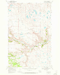
1968 Map of Big Rock
USGS Topo · Published 1972About this map
The Two Medicine River carves a deep, winding path through this portion of the Blackfeet Indian Reservation, creating a landscape defined by dramatic elevation changes and seasonal water flow. Surveyed in the late 1960s, the terrain is dotted with Numerous small kettle ponds and springs, suggesting a glacial history that has shaped the drainage patterns of the South Fork and Deep Creek.
Find a feature on this map
11 named features on this map. Tap any name to fly to it.
Don’t see what you’re looking for? This feature index may not catch every label — zoom into the map to look around manually.
Map Details
Editions of this 1968 Big Rock Map
This is the sole edition of this map. No revisions or reprints were ever made.
Other maps of this area

1901 · Browning
USGS Topo · 1:125,000

1903 · Browning
USGS Topo · 1:125,000

1911 · Blackfoot
USGS Topo · 1:125,000

1913 · Marias Pass
USGS Topo · 1:125,000

1914 · Heart Butte
USGS Topo · 1:125,000

1918 · Heart Butte
USGS Topo · 1:125,000

1960 · Cut Bank
USGS Topo · 1:250,000

1963 · Cut Bank
USGS Topo · 1:250,000

1964 · Cut Bank
USGS Topo · 1:250,000

1968 · Half Dome Crag
USGS Topo · 1:24,000