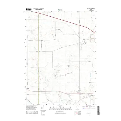
2015 Map of Big Rock
USGS Topo · Published 2015About this map
The agrarian landscape of western Kane County is meticulously detailed here, defined by the winding course of Big Rock Creek and its many tributaries like Welch Cr and Swan Drain. This area shows the intersection of historic rural communities and modern transportation corridors, with the village of Kaneville serving as a central hub for the surrounding township. Significant local history markers include several burial sites such as the Kaneville Cem and West Big Rock Cem, alongside the Community Methodist Cem near the small settlement of Troxel. The terrain is marked by a complex network of drainage systems like the Malgren Drain and Duffin Drain, which support the intensive agriculture of the region. Transportation is anchored by major routes such as Main ST and Dauberman RD, while aviation history is represented by the J Maddock Airport near the town of Big Rock.
Find a feature on this map
54 named features on this map. Tap any name to fly to it.
Don’t see what you’re looking for? This feature index may not catch every label — zoom into the map to look around manually.
Map Details
Editions of this 2015 Big Rock Map
This is the sole edition of this map. No revisions or reprints were ever made.
Other maps of this area

1925 · Yorkville
USGS Topo · 1:62,500

1932 · Geneva
USGS Topo · 1:62,500

1937 · Sycamore
USGS Topo · 1:62,500

1948 · Geneva
USGS Topo · 1:62,500

1948 · Sandwich
USGS Topo · 1:62,500

1950 · Sandwich
USGS Topo · 1:62,500

1953 · Yorkville
USGS Topo · 1:24,000
1954 · Yorkville
USGS Topo · 1:62,500

1958 · Aurora
USGS Topo · 1:250,000

1961 · Aurora
USGS Topo · 1:250,000