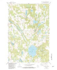
1983 Map of Big Round Lake
USGS Topo · Published 1983About this map
Big Round Lake dominates the central basin of this landscape in the early 1980s, serving as a focal point for the surrounding Georgetown and Johnstown townships. The map documents a terrain defined by glacial activity, where numerous kettle lakes like Bone Lake and Big Blake Lake are separated by sections of wetland such as Devils Marsh. The eastern portion of the sheet highlights the St Croix Indian Reservation near Loon Lake, while localized community history is preserved through the locations of the Johnstown Cem, Round Lake Chapel, and Zion Ch. Conservation and recreation are primary themes, evidenced by the expansive Mc Kenzie Creek State Public Hunting Grounds and several public access points and boat ramps that dot the shorelines of the larger water bodies like McKenzie Lake.
Find a feature on this map
52 named features on this map. Tap any name to fly to it.
Don’t see what you’re looking for? This feature index may not catch every label — zoom into the map to look around manually.
Map Details
Editions of this 1983 Big Round Lake Map
This is the sole edition of this map. No revisions or reprints were ever made.
Other maps of this area

1950 · Balsam Lake
USGS Topo · 1:62,500

1950 · Turtle Lake
USGS Topo · 1:62,500

1951 · Cumberland
USGS Topo · 1:48,000

1951 · Frederic
USGS Topo · 1:48,000

1952 · Turtle Lake
USGS Topo · 1:62,500

1953 · Stillwater
USGS Topo · 1:250,000

1955 · Frederic
USGS Topo · 1:62,500

1955 · Stillwater
USGS Topo · 1:250,000

1956 · Cumberland
USGS Topo · 1:62,500

1958 · Stillwater
USGS Topo · 1:250,000