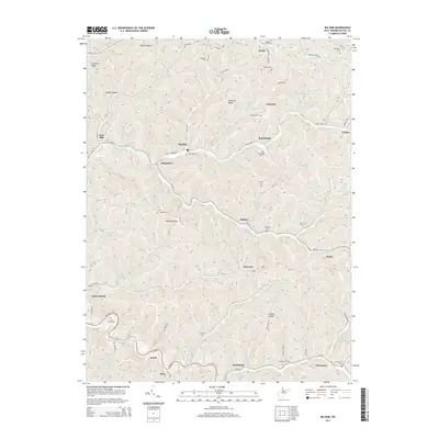
2014 Map of Big Run
USGS Topo · Published 2014About this map
Smithfield and Pricetown anchor the southern reaches of this West Virginia landscape, where the deeply incised drainage of North Fork Fishing Creek and its many tributaries dictates the pattern of settlement. Winding roads follow the narrow valley floors, connecting small communities like Kodol, Burchfield, and Mobley. The terrain is characterized by prominent ridges such as Creswell Ridge and Anderson Ridge, which separate the hollows where numerous family cemeteries are found. These sites, including the Utt Cem, Willey Cem, and Kilcoyne Cem, provide a dense record of the area's ancestral lineage. The map reveals a rural economy shaped by geography, with homes and small post offices clustered along waterways like Wiley Fork and Price Run, while higher elevations such as Lowman Ridge and Gilbert Ridge remain largely dominated by the natural topography of the Appalachian plateau.
Find a feature on this map
87 named features on this map. Tap any name to fly to it.
Don’t see what you’re looking for? This feature index may not catch every label — zoom into the map to look around manually.
Map Details
Editions of this 2014 Big Run Map
This is the sole edition of this map. No revisions or reprints were ever made.
Other maps of this area

1902 · Clarksburg
USGS Topo · 1:62,500

1903 · Littleton
USGS Topo · 1:62,500

1905 · Mannington
USGS Topo · 1:62,500

1905 · Centerpoint
USGS Topo · 1:62,500

1905 · Littleton
USGS Topo · 1:62,500

1910 · Clarksburg
USGS Topo · 1:62,500

1923 · Mannington
USGS Topo · 1:62,500

1923 · Clarksburg
USGS Topo · 1:62,500

1924 · Centerpoint
USGS Topo · 1:62,500

1924 · Littleton
USGS Topo · 1:62,500