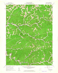
1960 Map of Big Run
USGS Topo · Published 1962About this map
The hills and hollows of Wetzel County in 1960 are defined by an extensive network of extractive industry and ridge-top settlements. Hundreds of Gas Wells and unlabeled oil wells dot the landscape, connected by a maze of pipelines and unimproved roads. Along the southern edge, the Baltimore and Ohio railroad corridor follows South Fork Fishing Creek, serving the communities of Smithfield and Pricetown.
Find a feature on this map
47 named features on this map. Tap any name to fly to it.
Don’t see what you’re looking for? This feature index may not catch every label — zoom into the map to look around manually.
Map Details
Editions of this 1960 Big Run Map
2 editions found
Other maps of this area

1902 · Clarksburg
USGS Topo · 1:62,500

1903 · Littleton
USGS Topo · 1:62,500

1905 · Mannington
USGS Topo · 1:62,500

1905 · Centerpoint
USGS Topo · 1:62,500

1905 · Littleton
USGS Topo · 1:62,500

1910 · Clarksburg
USGS Topo · 1:62,500

1923 · Mannington
USGS Topo · 1:62,500

1923 · Clarksburg
USGS Topo · 1:62,500

1924 · Centerpoint
USGS Topo · 1:62,500

1924 · Littleton
USGS Topo · 1:62,500