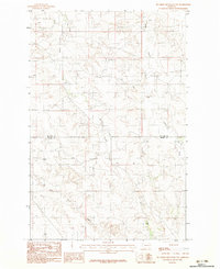
1983 Map of Big Sheep Mountain NW
USGS Topo · Published 1983About this map
Ash Creek flows through this eastern Montana landscape, marking the transition between Mc Cone Co and Prairie Co. The drainage patterns of Pasture Creek and East Duck Creek define the topography, illustrating the watershed structure of the region during the early 1980s. This provisional survey captures the intersection of county lines in a largely open area, where the terrain is dominated by these seasonal watercourses and the survey markers of the period. The map provides a detailed view of the natural hydrology of the area before modern land-use changes, serving as a primary source for understanding the physical geography and administrative boundaries of this portion of the Montana plains.
Find a feature on this map
4 named features on this map. Tap any name to fly to it.
Don’t see what you’re looking for? This feature index may not catch every label — zoom into the map to look around manually.
Map Details
Editions of this 1983 Big Sheep Mountain NW Map
This is the sole edition of this map. No revisions or reprints were ever made.
Other maps of this area

1954 · Glendive
USGS Topo · 1:250,000

1957 · Glendive
USGS Topo · 1:250,000

1958 · Glendive
USGS Topo · 1:250,000

1965 · Watkins SE
USGS Topo · 1:24,000

1965 · Watkins
USGS Topo · 1:24,000

1982 · Circle
USGS Topo · 1:100,000
1983 · Becker Dam
USGS Topo · 1:24,000
1983 · Big Sheep Mountain
USGS Topo · 1:24,000

1983 · Quick Reservoir
USGS Topo · 1:24,000
1983 · Brockway
USGS Topo · 1:24,000