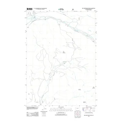
2012 Map of Big Sheep Mountain
USGS Topo · Published 2012About this map
Big Bend serves as a focal point in this high-altitude landscape where the Green River carves its path through Sublette County. The map captures a high-mountain drainage system defined by the prominent peaks of Big Sheep Mountain and Battleship Mountain. Access to this remote backcountry is traced through a series of specialized routes like Green River Lakes Rd and Gypsum Creek Rd, which follow the natural contours of the river valleys. The drainage of Gypsum Cr and its tributaries, including S Fork Gypsum Cr, dominate the central and southern portions of the quadrangle. Local landmarks such as Gypsum Park and Red Hill provide specific orientation points for those navigating this wilderness area, while Mud Lake and the Roaring Fork highlight the intricate hydrography found at the edge of the mountains.
Find a feature on this map
19 named features on this map. Tap any name to fly to it.
Don’t see what you’re looking for? This feature index may not catch every label — zoom into the map to look around manually.
Map Details
Editions of this 2012 Big Sheep Mountain Map
This is the sole edition of this map. No revisions or reprints were ever made.
Other maps of this area

1907 · Gros Ventre
USGS Topo · 1:125,000

1909 · Fremont Peak
USGS Topo · 1:125,000

1910 · Gros Ventre
USGS Topo · 1:125,000

1955 · Driggs
USGS Topo · 1:250,000

1955 · Thermopolis
USGS Topo · 1:250,000

1958 · Driggs
USGS Topo · 1:250,000

1958 · Thermopolis
USGS Topo · 1:250,000

1962 · Thermopolis
USGS Topo · 1:250,000

1962 · Driggs
USGS Topo · 1:250,000
1966 · Dodge Butte
USGS Topo · 1:24,000