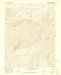
1965 Map of Big Soap Park
USGS Topo · Published 1968About this map
Gunnison National Forest dominates this mid-1960s survey of high-elevation terrain, defined by the drainage basins of the West and East forks of Soap Creek. The West Elk Wilderness occupies the eastern portion of the sheet, where steep drainages like Smooth Canyon cut through the landscape. Settlement is minimal in this wilderness-focused region, though the Waterman Ranch is noted near the center of Big Soap Park, providing a rare point of human habitation in a landscape otherwise defined by pack trails and prominent peaks.
Find a feature on this map
50 named features on this map. Tap any name to fly to it.
Don’t see what you’re looking for? This feature index may not catch every label — zoom into the map to look around manually.
Map Details
Editions of this 1965 Big Soap Park Map
4 editions found
Other maps of this area

1888 · Anthracite
USGS Topo · 1:62,500

1889 · Anthracite
USGS Topo · 1:62,500

1893 · Anthracite
USGS Topo · 1:62,500

1894 · Anthracite
USGS Topo · 1:62,500

1938 · Mt. Gunnison
USGS Topo · 1:48,000

1945 · Mount Gunnison
USGS Topo · 1:62,500

1954 · West Elk Peak SW
USGS Topo · 1:24,000

1954 · Little Soap Park
USGS Topo · 1:24,000

1956 · Montrose
USGS Topo · 1:250,000

1957 · X Lazy F Ranch
USGS Topo · 1:24,000