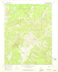
1965 Map of Big Soap Park
USGS Topo · Published 1975About this map
Waterman Ranch sits as a primary point of human settlement within this mid-1960s survey of high-elevation terrain north of Blue Mesa. The landscape is dominated by the complex drainage systems of Soap Creek, including the West Soap Creek and East Soap Creek forks, which carve deep into the Gunnison National Forest. A vast network of travel is documented through numerous pack trails and the Zack Trail, which provided essential access for ranching and forest management before the expansion of modern road systems in this part of the Western Slope.
Find a feature on this map
27 named features on this map. Tap any name to fly to it.
Don’t see what you’re looking for? This feature index may not catch every label — zoom into the map to look around manually.
Map Details
Editions of this 1965 Big Soap Park Map
4 editions found
Other maps of this area

1888 · Anthracite
USGS Topo · 1:62,500

1889 · Anthracite
USGS Topo · 1:62,500

1893 · Anthracite
USGS Topo · 1:62,500

1894 · Anthracite
USGS Topo · 1:62,500

1938 · Mt. Gunnison
USGS Topo · 1:48,000

1945 · Mount Gunnison
USGS Topo · 1:62,500

1954 · West Elk Peak SW
USGS Topo · 1:24,000

1954 · Little Soap Park
USGS Topo · 1:24,000

1956 · Montrose
USGS Topo · 1:250,000

1957 · X Lazy F Ranch
USGS Topo · 1:24,000