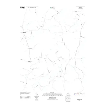
2013 Map of Big Spring
USGS Topo · Published 2013About this map
Big Spring and Bewleyville anchor this agricultural landscape in Breckinridge County, defined by a network of rural roads and family-named landmarks. The terrain is notably marked by numerous sinkholes and depressions characteristic of karst topography, particularly around the settlements of Corners and High Plains. Several roads, such as Guston-Bewleyville Rd and Irvington-Bewleyville Rd, serve as primary connectors between these rural communities, while family names like Nannie Ammons Rd and Herbert Carman Rd reflect the deep-rooted local heritage of the area. To the south, the landscape is bisected by the Blue Fork waterway, which meanders through the hills near High Plains Corner. The map's layout of small-scale roads and intersections, including Maples Corner, illustrates the persistent rural character of this Kentucky region into the early 21st century.
Find a feature on this map
49 named features on this map. Tap any name to fly to it.
Don’t see what you’re looking for? This feature index may not catch every label — zoom into the map to look around manually.
Map Details
Editions of this 2013 Big Spring Map
This is the sole edition of this map. No revisions or reprints were ever made.
Other maps of this area

1928 · Hardinsburg
USGS Topo · 1:48,000

1931 · Hardinsburg
USGS Topo · 1:62,500

1932 · Big Clifty
USGS Topo · 1:62,500

1941 · Ekron
USGS Topo · 1:62,500

1946 · Rock Haven
USGS Topo · 1:24,000

1947 · Irvington
USGS Topo · 1:24,000

1947 · Garfield
USGS Topo · 1:24,000

1947 · Hardinsburg
USGS Topo · 1:62,500

1947 · Ekron
USGS Topo · 1:62,500
1948 · Guston
USGS Topo · 1:24,000