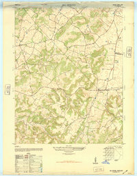
1948 Map of Big Spring
USGS Topo · Published 1948About this map
The community of Big Spring serves as a focal point on this 1948 topographic study, where local travel was defined by naming conventions like the Rineyville and Big Spring Road. The landscape is characterized by its numerous small valleys and ridges, with the rural infrastructure of the era clearly marked by specialized schools such as Bewleyville School and Schmuck School. Local roads often reflect specific landmarks, as seen with the Flaherty Church and John Burnett Road.
Find a feature on this map
17 named features on this map. Tap any name to fly to it.
Don’t see what you’re looking for? This feature index may not catch every label — zoom into the map to look around manually.
Map Details
Editions of this 1948 Big Spring Map
This is the sole edition of this map. No revisions or reprints were ever made.
Other maps of this area

1928 · Hardinsburg
USGS Topo · 1:48,000

1931 · Hardinsburg
USGS Topo · 1:62,500

1932 · Big Clifty
USGS Topo · 1:62,500

1941 · Ekron
USGS Topo · 1:62,500

1946 · Rock Haven
USGS Topo · 1:24,000

1947 · Irvington
USGS Topo · 1:24,000

1947 · Garfield
USGS Topo · 1:24,000

1947 · Hardinsburg
USGS Topo · 1:62,500

1947 · Ekron
USGS Topo · 1:62,500
1948 · Guston
USGS Topo · 1:24,000