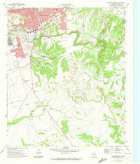
1971 Map of Big Spring South
USGS Topo · Published 1974About this map
Big Spring serves as the focal point of this 1970s topographic study, showing a West Texas community defined by its educational infrastructure and energy production. The city's residential growth is evidenced by numerous institutions including College Heights Sch, Goliad Jr High Sch, and Runnels Jr High Sch. To the southwest, a large Oil Field and an extensive network of Gravel Pits highlight the local industrial economy.
Find a feature on this map
38 named features on this map. Tap any name to fly to it.
Don’t see what you’re looking for? This feature index may not catch every label — zoom into the map to look around manually.
Map Details
Editions of this 1971 Big Spring South Map
2 editions found
Other maps of this area

1941 · Morita
USGS Topo · 1:62,500

1941 · Big Spring South
USGS Topo · 1:62,500

1942 · Big Spring South
USGS Topo · 1:62,500

1942 · Big Spring North
USGS Topo · 1:62,500

1949 · Morita
USGS Topo · 1:62,500

1954 · Big Spring
USGS Topo · 1:250,000

1954 · Big Spring North
USGS Topo · 1:24,000

1958 · Big Spring
USGS Topo · 1:250,000

1965 · Big Spring North
USGS Topo · 1:24,000
1966 · Lucian Wells Ranch
USGS Topo · 1:24,000