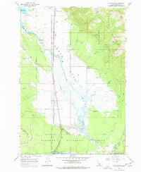
1964 Map of Big Springs
USGS Topo · Published 1977About this map
Henrys Fork snakes through the center of this 1964 survey, defining the landscape of Henrys Lake Flat before the river reaches the southern recreation areas. The map details the transition from the high peaks of the Henrys Lake Mountains, including Mount Two Top, down to the marshy lowlands fed by numerous tributaries like Crooked Creek and Jones Creek. A significant portion of the area is managed as part of the Targhee National Forest, where the topography shifts from steep canyons like White Elephant Canyon to the broad expanses of Stamp Meadows.
Find a feature on this map
38 named features on this map. Tap any name to fly to it.
Don’t see what you’re looking for? This feature index may not catch every label — zoom into the map to look around manually.
Map Details
Editions of this 1964 Big Springs Map
2 editions found

Other maps of this area

1955 · Ashton
USGS Topo · 1:250,000

1957 · Buffalo Lake
USGS Topo · 1:62,500

1958 · Ashton
USGS Topo · 1:250,000

1958 · West Yellowstone
USGS Topo · 1:62,500

1960 · Ashton
USGS Topo · 1:250,000

1964 · Island Park
USGS Topo · 1:24,000

1964 · Island Park Dam
USGS Topo · 1:24,000

1964 · Targhee Pass
USGS Topo · 1:24,000

1964 · Targhee Peak
USGS Topo · 1:24,000

1964 · Sawtell PK
USGS Topo · 1:24,000