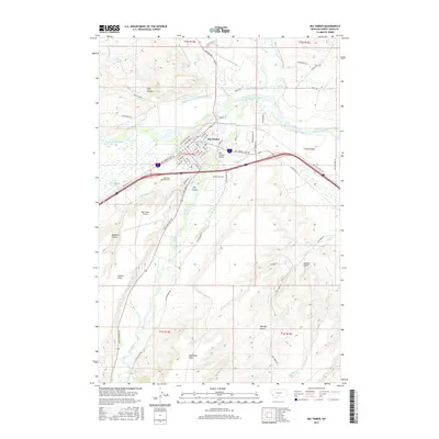
2017 Map of Big Timber
USGS Topo · Published 2017About this map
Big Timber sits at the confluence of the Yellowstone River and the Boulder River, serving as a hub for local agriculture and transportation. The landscape is defined by an intricate network of irrigation canals, including the Mauland-Rapstad Ditch, Arneson-Ditch, and Post-Kellogg Ditch, which redirect water from the river systems to support the surrounding McKenzie Flats and Airport Flats. This reliance on water management is a hallmark of the region's ranching and farming heritage.
Find a feature on this map
78 named features on this map. Tap any name to fly to it.
Don’t see what you’re looking for? This feature index may not catch every label — zoom into the map to look around manually.
Map Details
Editions of this 2017 Big Timber Map
This is the sole edition of this map. No revisions or reprints were ever made.
Other maps of this area

1891 · Livingston
USGS Topo · 1:250,000

1891 · Big Timber
USGS Topo · 1:125,000

1893 · Livingston
USGS Topo · 1:250,000

1893 · Big Timber
USGS Topo · 1:125,000

1947 · Bozeman
USGS Topo · 1:250,000

1948 · Bozeman
USGS Topo · 1:250,000
1951 · Grosfield Ranch
USGS Topo · 1:24,000
1951 · Mc Leod
USGS Topo · 1:24,000
1951 · Carney
USGS Topo · 1:24,000

1954 · Big Timber
USGS Topo · 1:24,000