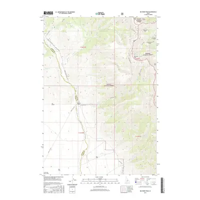
2017 Map of Big Windy Peak
USGS Topo · Published 2017About this map
Big Windy Peak serves as a prominent high point along the boundary of the Salmon National Forest, Targhee National Forest, and Challis National Forest. This 2017 survey details a high-elevation landscape defined by deep drainages and ridges, where the Lemhi and Custer county line follows the winding course of Sawmill Creek. The terrain transitions from the steep slopes of Spring Mtn and Trail Peak in the east to the lower Deer Flats and Mud Flats in the southwest, where the land opens toward the Little Lost River Valley. Access through this wilderness is provided by forest service routes like the Sawmill Canyon Road - FR 101 and the Warm Creek Trail. The map documents numerous seasonal water sources and named geographic features such as Quartzite Canyon and Horseshoe Gulch, illustrating the complex topography of the Lemhi Range.
Find a feature on this map
43 named features on this map. Tap any name to fly to it.
Don’t see what you’re looking for? This feature index may not catch every label — zoom into the map to look around manually.
Map Details
Editions of this 2017 Big Windy Peak Map
This is the sole edition of this map. No revisions or reprints were ever made.
Other maps of this area

1955 · Dubois
USGS Topo · 1:250,000

1956 · Nicholia
USGS Topo · 1:62,500

1957 · Diamond Peak
USGS Topo · 1:62,500

1957 · Gilmore
USGS Topo · 1:62,500

1957 · Hawley Mountain
USGS Topo · 1:62,500

1958 · Dubois
USGS Topo · 1:250,000

1987 · Gilmore
USGS Topo · 1:24,000
1987 · Mulkey Bar
USGS Topo · 1:24,000
1987 · Gilmore Summit
USGS Topo · 1:24,000
1987 · Bell Mountain
USGS Topo · 1:24,000