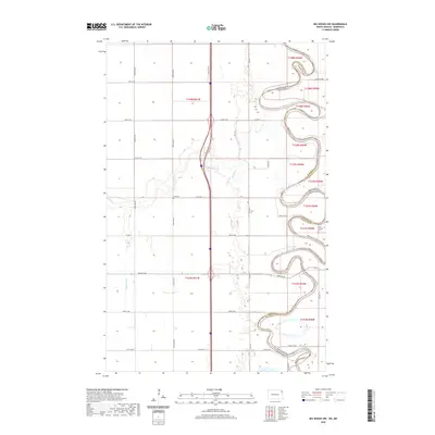
2020 Map of Big Woods NW
USGS Topo · Published 2020About this map
Red River of the North snakes along the boundary between North Dakota and Minnesota, defining a landscape of deep meanders and fertile bottomlands in this 2020 survey. This section of Walsh County is characterized by its meticulous drainage network and grid-based rural road system, where the Park River and Dipple Drain cut through the plains to join the larger river system. Local heritage is centered around long-standing community landmarks such as Zion Cem and Saint Joseph's Cem, reflecting the area's deep-rooted agricultural and spiritual history. The map captures the interface between Walsh Co and Marshall Co, illustrating how the waterway serves as both a geographic barrier and a connective thread for the border communities.
Find a feature on this map
35 named features on this map. Tap any name to fly to it.
Don’t see what you’re looking for? This feature index may not catch every label — zoom into the map to look around manually.
Map Details
Editions of this 2020 Big Woods NW Map
This is the sole edition of this map. No revisions or reprints were ever made.
Other maps of this area

1918 · Acton
USGS Topo · 1:62,500

1939 · Drayton
USGS Topo · 1:62,500

1939 · Glasston
USGS Topo · 1:62,500

1941 · Drayton
USGS Topo · 1:62,500

1941 · Glasston
USGS Topo · 1:62,500

1943 · Grafton
USGS Topo · 1:62,500

1952 · Thief River Falls
USGS Topo · 1:250,000

1956 · Thief River Falls
USGS Topo · 1:250,000

1957 · Thief River Falls
USGS Topo · 1:250,000
1960 · Big Woods NW
USGS Topo · 1:24,000