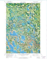
1970 Map of Bigfork
USGS Topo · Published 1973About this map
Big Fork River meanders through the northern reaches of Itasca County, defining a landscape of complex water systems and managed forests. This 1970 orthophotomap provides a hybrid view of the region, where the town of Bigfork serves as a small hub near Lakeview Cem and several industrial sandpits. The terrain is characterized by the transition between the Big Fork State Forest and the Chippewa National Forest, marked by an extensive network of waterways including the expansive Turtle Lake and the smaller, intricately shaped Bello Lake.
Find a feature on this map
51 named features on this map. Tap any name to fly to it.
Don’t see what you’re looking for? This feature index may not catch every label — zoom into the map to look around manually.
Map Details
Editions of this 1970 Bigfork Map
This is the sole edition of this map. No revisions or reprints were ever made.
Other maps of this area

1918 · Zora
USGS Topo · 1:62,500

1919 · Zora
USGS Topo · 1:62,500

1919 · Marcell
USGS Topo · 1:62,500

1954 · Hibbing
USGS Topo · 1:250,000

1957 · Hibbing
USGS Topo · 1:250,000

1958 · Hibbing
USGS Topo · 1:250,000

1964 · Hibbing
USGS Topo · 1:250,000

1970 · Clubhouse Lake
USGS Topo · 1:24,000

1970 · Jessie Lake
USGS Topo · 1:24,000

1970 · Coon Lake
USGS Topo · 1:24,000