
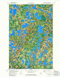
1970 Map of Clubhouse Lake
USGS Topo · Published 1973About this map
The dense forests and interlocking glacial lakes of northern Itasca County define this landscape during a 1970 field survey. This orthophotomap provides a rare overhead look at the region's wilderness character, where the boundaries of the Chippewa National Forest meet the George Washington State Forest and Bowstring State Forest. The map is particularly notable for its detailed view of the water-rich topography, highlighting large bodies like Clubhouse Lake and Gunn Lake alongside smaller, uniquely named features such as Ghost Lake, Mikes Lake, and Copenhagen Lake.
Find a feature on this map
70 named features on this map. Tap any name to fly to it.
Don’t see what you’re looking for? This feature index may not catch every label — zoom into the map to look around manually.
Map Details
Editions of this 1970 Clubhouse Lake Map
2 editions found
Other maps of this area

1919 · Release
USGS Topo · 1:62,500

1919 · Marcell
USGS Topo · 1:62,500

1920 · Trout Lake
USGS Topo · 1:62,500

1943 · Release
USGS Topo · 1:62,500

1954 · Hibbing
USGS Topo · 1:250,000

1957 · Hibbing
USGS Topo · 1:250,000

1958 · Hibbing
USGS Topo · 1:250,000

1964 · Hibbing
USGS Topo · 1:250,000

1970 · Wabana Lake
USGS Topo · 1:24,000

1970 · Coon Lake
USGS Topo · 1:24,000