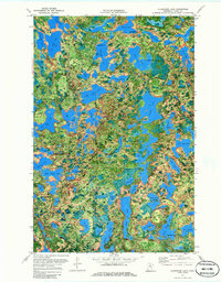
1970 Map of Clubhouse Lake
USGS Topo · Published 1986About this map
Chippewa National Forest and the intersecting boundaries of the George Washington State Forest and Bowstring State Forest dominate this intricate water-land interface in Itasca County. The landscape is defined by a dense network of glacial lakes, ranging from the expansive Gunn Lake to smaller, isolated basins like Copenhagen Lake and Ghost Lake. This orthophotomap, based on 1969 aerial photography, reveals the complex timber and recreational patterns of the mid-century North Woods. Recreational development is evident at the Girl Scout Camp and several designated Campground sites, while Public Access points at Clubhouse Lake and Highland Lake suggest the area's importance for local angling and seasonal use. The detailed hydrography, including Three Island Lake and Black Island Lake, illustrates a transition zone where state and federal forest management priorities overlap amidst an nearly continuous chain of waterways.
Find a feature on this map
76 named features on this map. Tap any name to fly to it.
Don’t see what you’re looking for? This feature index may not catch every label — zoom into the map to look around manually.
Map Details
Editions of this 1970 Clubhouse Lake Map
2 editions found
Other maps of this area

1919 · Release
USGS Topo · 1:62,500

1919 · Marcell
USGS Topo · 1:62,500

1920 · Trout Lake
USGS Topo · 1:62,500

1943 · Release
USGS Topo · 1:62,500

1954 · Hibbing
USGS Topo · 1:250,000

1957 · Hibbing
USGS Topo · 1:250,000

1958 · Hibbing
USGS Topo · 1:250,000

1964 · Hibbing
USGS Topo · 1:250,000

1970 · Wabana Lake
USGS Topo · 1:24,000

1970 · Clubhouse Lake
USGS Topo · 1:24,000