
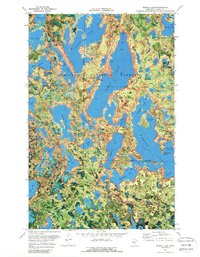
1970 Map of Wabana Lake
USGS Topo · Published 1973About this map
Chippewa National Forest dominates this orthophotomap of Itasca County, where a complex network of glacial lakes defines the landscape. The intricate shorelines of Trout Lake and Spider Lake are captured with photographic detail, showing the dense timber and varying elevations of the northern Minnesota lake country. Unlike traditional topographic maps, this edition uses aerial photography from 1969 to illustrate the actual vegetation and land use patterns of the era.
Find a feature on this map
57 named features on this map. Tap any name to fly to it.
Don’t see what you’re looking for? This feature index may not catch every label — zoom into the map to look around manually.
Map Details
Editions of this 1970 Wabana Lake Map
2 editions found
Other maps of this area

1919 · Release
USGS Topo · 1:62,500

1919 · Marcell
USGS Topo · 1:62,500

1920 · Trout Lake
USGS Topo · 1:62,500

1943 · Release
USGS Topo · 1:62,500

1952 · Bovey
USGS Topo · 1:24,000

1953 · Cohasset East
USGS Topo · 1:24,000

1953 · Cohasset West
USGS Topo · 1:24,000

1954 · Hibbing
USGS Topo · 1:250,000

1957 · Hibbing
USGS Topo · 1:250,000

1958 · Hibbing
USGS Topo · 1:250,000