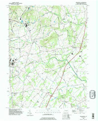
1990 Map of Biglerville
USGS Topo · Published 1995About this map
The agricultural and forested landscape of Adams County is defined here by a series of low ridges like Chestnut Hill and Stone Jug Hill, which separate the various drainages of Conewago Creek and Bermudian Creek. In the early 1990s, this region maintained a dense network of small villages and crossroads, including Biglerville, Bendersville, and Heidlersburg. The area's milling history is still visible at Limerick Mill and Center Mill, while the local social fabric is anchored by numerous country churches such as Rock Chapel and Great Conewago Ch.
Find a feature on this map
68 named features on this map. Tap any name to fly to it.
Don’t see what you’re looking for? This feature index may not catch every label — zoom into the map to look around manually.
Map Details
Editions of this 1990 Biglerville Map
This is the sole edition of this map. No revisions or reprints were ever made.
Other maps of this area

1904 · Carlisle
USGS Topo · 1:62,500

1908 · Gettysburg
USGS Topo · 1:62,500

1909 · Fairfield
USGS Topo · 1:62,500

1919 · Newville
USGS Topo · 1:62,500

1942 · Gettysburg
USGS Topo · 1:125,000

1943 · Carlisle
USGS Topo · 1:62,500

1944 · Gettysburg
USGS Topo · 1:31,680

1944 · Mc Sherrystown
USGS Topo · 1:31,680

1944 · Arendtsville
USGS Topo · 1:31,680
1944 · Fairfield
USGS Topo · 1:31,680
Featured Places
- Biglerville, PA
- Bendersville, PA
- Huntington Township, PA
- Aspers, Menallen Township
- Center Mills, Butler Township