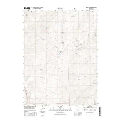
2014 Map of Billies Mountain
USGS Topo · Published 2014About this map
The Wasatch Range dominates this portion of the Uinta National Forest, where the landscape is defined by a dense network of drainages and named canyons. In the northern reaches, Maple Canyon and Dibbles Canyon cut through the high ground, while further south, the prominence of Billies Mtn stands near the junction of US Hwy 6, 89 and the canyon floors. The map reveals a specific recreational geography concentrated along the waterways, with Palmyra Campground and Diamond Campground situated where Little Diamond Cr meets the larger Diamond Fork.
Find a feature on this map
34 named features on this map. Tap any name to fly to it.
Don’t see what you’re looking for? This feature index may not catch every label — zoom into the map to look around manually.
Map Details
Editions of this 2014 Billies Mountain Map
This is the sole edition of this map. No revisions or reprints were ever made.
Other maps of this area

1885 · Salt Lake
USGS Topo · 1:250,000

1885 · Manti
USGS Topo · 1:250,000

1895 · Manti
USGS Topo · 1:250,000

1907 · Strawberry Valley
USGS Topo · 1:125,000

1909 · Strawberry Valley
USGS Topo · 1:125,000

1948 · Springville
USGS Topo · 1:24,000

1949 · Provo
USGS Topo · 1:62,500

1949 · Spanish Fork Peak
USGS Topo · 1:24,000
1950 · Springville
USGS Topo · 1:24,000

1951 · Spanish Fork Peak
USGS Topo · 1:24,000