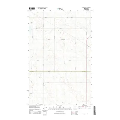
2014 Map of Billings Lake
USGS Topo · Published 2014About this map
Nekoma sits at the intersection of a vast grid of section roads and the diagonal path of Railroad Ave, serving as the primary hub for this agricultural landscape on the Cavalier and Ramsey County line. The terrain is defined by the subtle drainage patterns of the Edmore Coulee and Nekoma Coulee, which wind through the prairie toward Billings Lake. This 2014 survey captures a moment when the rural road network, including routes like Nd-1, remains the lifeblood of the region, connecting isolated farmsteads across the township. The strictly rectangular township-and-range grid is momentarily interrupted only by these natural coulees and the legacy of the rail corridor, illustrating the tension between the deliberate human ordering of the Great Plains and the geological reality of its ancient drainage basins.
Find a feature on this map
22 named features on this map. Tap any name to fly to it.
Don’t see what you’re looking for? This feature index may not catch every label — zoom into the map to look around manually.
Map Details
Editions of this 2014 Billings Lake Map
This is the sole edition of this map. No revisions or reprints were ever made.
Other maps of this area
1953 · Devils Lake
USGS Topo · 1:250,000
1956 · Devils Lake
USGS Topo · 1:250,000
1970 · Loma
USGS Topo · 1:24,000
1970 · Alsen SE
USGS Topo · 1:24,000
1972 · Derrick
USGS Topo · 1:24,000
1972 · Nekoma
USGS Topo · 1:24,000
1972 · Easby
USGS Topo · 1:24,000
1972 · Edmore
USGS Topo · 1:24,000
1972 · Edmore NE
USGS Topo · 1:24,000
1972 · Billings Lake
USGS Topo · 1:24,000