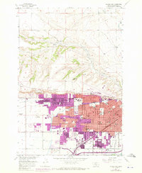
1957 Map of Billings West
USGS Topo · Published 1970About this map
The Rimrocks formation stands as the defining geologic barrier overlooking the burgeoning expansion of the city below. This mid-century survey documents the urban development of the Billings Bench and the growth surrounding major institutions like Eastern Montana College and Rocky Mountain College. Transportation networks are heavily represented by the Burlington Northern and Northern Pacific railroads, alongside the historic Lewis and Clark Trail. To the north, the landscape remains dominated by ranching, with the Twin Pines Ranch and several forks of Alkali Creek carving through the terrain. The map captures the transition from irrigated agriculture—evidenced by the Big Ditch, Snow Ditch, and Arnold Drain—into the residential and commercial blocks that defined the area by the 1960s. For the local historian, it provides an exact layout of vanished landmarks and civic centers, including Logan Field and the Naval Armory.
Find a feature on this map
75 named features on this map. Tap any name to fly to it.
Don’t see what you’re looking for? This feature index may not catch every label — zoom into the map to look around manually.
Map Details
Editions of this 1957 Billings West Map
3 editions found

Other maps of this area

1893 · Huntley
USGS Topo · 1:125,000

1954 · Billings
USGS Topo · 1:250,000

1956 · Rattlesnake Butte
USGS Topo · 1:24,000

1956 · Acton
USGS Topo · 1:24,000

1956 · Hickson Ranch
USGS Topo · 1:24,000

1956 · Rimrock
USGS Topo · 1:24,000

1956 · Yegen
USGS Topo · 1:24,000

1956 · Billings East
USGS Topo · 1:24,000

1956 · Mossmain
USGS Topo · 1:24,000

1957 · Billings
USGS Topo · 1:250,000