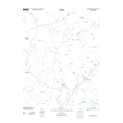
2013 Map of Billingsley Gap
USGS Topo · Published 2013About this map
Emery Mill and Cooper Mill anchor the southern reaches of this Bledsoe County landscape, where the terrain transitions toward the Sequatchie River valley. The map reveals a complex system of gaps and coves along the eastern ridge, including Billingsley Gap, Rankins Gap, and Walker Cove. The settlement pattern is defined by high-elevation hamlets like Tiptop and Mount Crest, connected by a network of rural roads such as Bledsoe Forest Rd and Saratoga Springs Rd. Notable water features include Hugh Clayborne Lake and Beecher Smith Lake, while the varied topography is named with colorful local identifiers like Devils Racepath and Rattlesnake Ridge. This record provides a detailed look at the rural infrastructure and land use in the Cumberland Plateau region during the early 21st century.
Find a feature on this map
126 named features on this map. Tap any name to fly to it.
Don’t see what you’re looking for? This feature index may not catch every label — zoom into the map to look around manually.
Map Details
Editions of this 2013 Billingsley Gap Map
This is the sole edition of this map. No revisions or reprints were ever made.
Other maps of this area

1892 · Pikeville
USGS Topo · 1:125,000

1895 · Pikeville
USGS Topo · 1:125,000

1909 · Sequatchie Valley
USGS Topo · 1:62,500

1910 · Pikeville
USGS Topo · 1:62,500

1912 · Crossville
USGS Topo · 1:62,500

1935 · Melvine
USGS Topo · 1:24,000

1935 · Morgan Springs
USGS Topo · 1:24,000

1935 · Brockdell
USGS Topo · 1:24,000

1935 · Billingsley Gap
USGS Topo · 1:24,000
1935 · Vandever
USGS Topo · 1:24,000