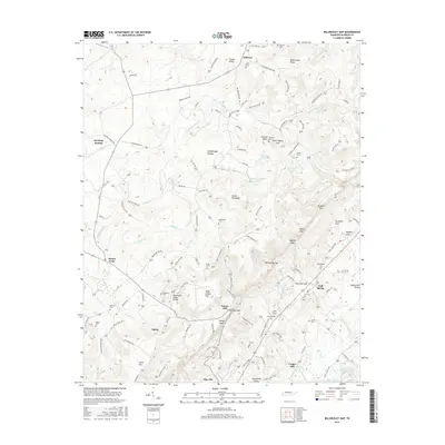
2016 Map of Billingsley Gap
USGS Topo · Published 2016About this map
Pikeville sits at the southern edge of the Sequatchie Valley, where the steep rise of the Cumberland Plateau dominates the landscape. The geography here is defined by sharp elevation changes, particularly at Billingsley Gap and Rankins Gap, which provide narrow passages through the escarpment. Settlements like Tiptop and Bellview are scattered across the higher plateau, while the Sequatchie River winds through the valley below. Local history is deeply etched into the land through numerous family burial sites, including the Blackburn Cem, Pendergrass Cem, and Beaverhill Cem. The map reveals a transition from the agricultural valley floor to the timbered heights, connected by winding routes like the Alvin C York Hwy and the Old Taft Hwy. Remnants of early community industry are noted at Emery Mill and Cooper Mill, marking the importance of water power along the valley's edge.
Find a feature on this map
128 named features on this map. Tap any name to fly to it.
Don’t see what you’re looking for? This feature index may not catch every label — zoom into the map to look around manually.
Map Details
Editions of this 2016 Billingsley Gap Map
This is the sole edition of this map. No revisions or reprints were ever made.
Other maps of this area

1892 · Pikeville
USGS Topo · 1:125,000

1895 · Pikeville
USGS Topo · 1:125,000

1909 · Sequatchie Valley
USGS Topo · 1:62,500

1910 · Pikeville
USGS Topo · 1:62,500

1912 · Crossville
USGS Topo · 1:62,500

1935 · Melvine
USGS Topo · 1:24,000

1935 · Morgan Springs
USGS Topo · 1:24,000

1935 · Brockdell
USGS Topo · 1:24,000

1935 · Billingsley Gap
USGS Topo · 1:24,000
1935 · Vandever
USGS Topo · 1:24,000