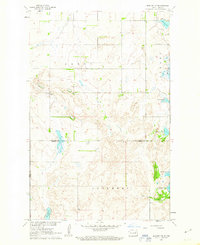
1961 Map of Binford NW
USGS Topo · Published 1963About this map
Glacial lake basins and high prairie ridges define this landscape along the borders of Nelson, Griggs, and Eddy counties in the early 1960s. The terrain is marked by a series of significant water bodies, including Red Willow Lake, Ottofy Lake, and the distinctly named Hoot-E-Too Lake. These natural features dictated the early settlement patterns of the townships of Forde, Bergen, and Rosendal. Local heritage is anchored by sites like the Bergen Ch Cem and St Johns Cem, which served the rural farming communities of the era. The presence of multiple Gravel Pits suggests an economy linked to local infrastructure and road maintenance as the region's agricultural footprint expanded. The map meticulously records the intersection of three county lines, reflecting the complex administrative boundaries of this prairie region.
Find a feature on this map
16 named features on this map. Tap any name to fly to it.
Don’t see what you’re looking for? This feature index may not catch every label — zoom into the map to look around manually.
Map Details
Editions of this 1961 Binford NW Map
This is the sole edition of this map. No revisions or reprints were ever made.
Other maps of this area

1930 · Pekin
USGS Topo · 1:62,500

1930 · Hamar
USGS Topo · 1:62,500

1951 · Tolna
USGS Topo · 1:24,000

1951 · Pekin
USGS Topo · 1:24,000

1951 · Pekin
USGS Topo · 1:62,500

1952 · New Rockford
USGS Topo · 1:250,000

1956 · New Rockford
USGS Topo · 1:250,000

1961 · McHenry
USGS Topo · 1:24,000

1961 · Binford
USGS Topo · 1:24,000

1961 · Johnson Lake
USGS Topo · 1:24,000