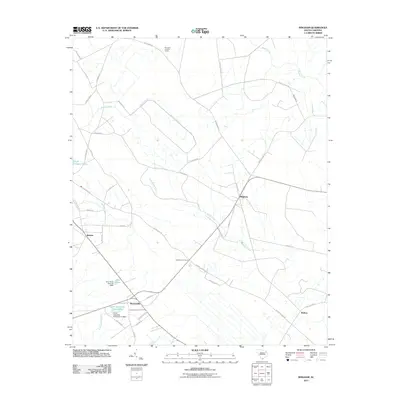
2011 Map of Bingham
USGS Topo · Published 2011About this map
Agricultural lands and water management systems define this part of Marlboro County, where the settlement of Bingham serves as a central point for the surrounding rural network. The landscape is interconnected by a series of creeks, including Little Reedy Creek and Reedy Creek, which feed into several engineered water bodies. These features, such as the Canal Industries Pond and Grey Pond, highlight the importance of water control and industry in the local economy during the early 21st century.
Find a feature on this map
44 named features on this map. Tap any name to fly to it.
Don’t see what you’re looking for? This feature index may not catch every label — zoom into the map to look around manually.
Map Details
Editions of this 2011 Bingham Map
This is the sole edition of this map. No revisions or reprints were ever made.
Other maps of this area

1942 · Rockingham
USGS Topo · 1:125,000

1943 · Gum Swamp
USGS Topo · 1:62,500

1953 · Florence
USGS Topo · 1:250,000

1954 · Florence
USGS Topo · 1:250,000

1960 · Latta
USGS Topo · 1:24,000

1960 · Dillon West
USGS Topo · 1:24,000

1971 · Minturn
USGS Topo · 1:24,000

1972 · Drake
USGS Topo · 1:24,000

1972 · Clio
USGS Topo · 1:24,000
1972 · Oak Grove
USGS Topo · 1:24,000