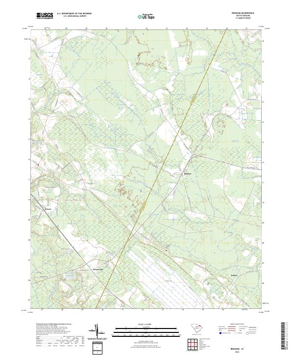
2024 Map of Bingham
USGS Topo · Published 2024About this map
Bingham and Brownsville anchor this rural landscape in Marlboro County, where the terrain is defined by a series of distinct elliptical depressions and complex water systems. The map illustrates a network of "bays"—characteristic of the Atlantic coastal plain—including Mossy Bay, Hilson Bay, Indigo Bay, and Pine Bay. These features, along with Catfish Bay, create a unique hydrologic pattern feeding into Little Reedy Creek and Rogers Creek. Modern infrastructure, such as the Canal Industries Pond Dam, sits alongside historic landmarks like the Timothy Rogers Cem, providing a clear record of local land use and family heritage.
Find a feature on this map
56 named features on this map. Tap any name to fly to it.
Don’t see what you’re looking for? This feature index may not catch every label — zoom into the map to look around manually.
Map Details
Editions of this 2024 Bingham Map
This is the sole edition of this map. No revisions or reprints were ever made.
Other maps of this area

1942 · Rockingham
USGS Topo · 1:125,000

1943 · Gum Swamp
USGS Topo · 1:62,500

1953 · Florence
USGS Topo · 1:250,000

1954 · Florence
USGS Topo · 1:250,000

1960 · Latta
USGS Topo · 1:24,000

1960 · Dillon West
USGS Topo · 1:24,000

1971 · Minturn
USGS Topo · 1:24,000

1972 · Drake
USGS Topo · 1:24,000

1972 · Clio
USGS Topo · 1:24,000
1972 · Oak Grove
USGS Topo · 1:24,000