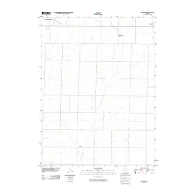
2010 Map of Bingham
USGS Topo · Published 2010About this map
Shenandoah occupies the northwestern corner of this Page County landscape, where the town street grid meets the expansive agricultural reaches of southwestern Iowa. The terrain is defined by a series of parallel waterways, including Fisher Creek, West Tarkio Creek, and Middle Tarkio Creek, which dictate the placement of farms and section roads. Small settlements such as Bingham and Norwich serve as landmarks along the section-line roads, illustrating the persistent rural settlement pattern of the early twenty-first century. One of the few non-agricultural landmarks is the Martin Cemetery, situated near the banks of West Tarkio Creek. The map also traces modern infrastructure like the Anna Crose Hwy, showing how contemporary transportation routes follow the established grid of local roads like A Ave and B Ave.
Find a feature on this map
26 named features on this map. Tap any name to fly to it.
Don’t see what you’re looking for? This feature index may not catch every label — zoom into the map to look around manually.
Map Details
Editions of this 2010 Bingham Map
This is the sole edition of this map. No revisions or reprints were ever made.
Other maps of this area

1939 · Farragut
USGS Topo · 1:62,500

1940 · Farragut
USGS Topo · 1:62,500

1940 · Coin
USGS Topo · 1:62,500

1943 · Coin
USGS Topo · 1:62,500

1955 · Nebraska City
USGS Topo · 1:250,000

1957 · Nebraska City
USGS Topo · 1:250,000

1958 · Nebraska City
USGS Topo · 1:250,000

1978 · Shenandoah East
USGS Topo · 1:24,000

1978 · Stanton SW
USGS Topo · 1:24,000
1978 · Shenandoah West
USGS Topo · 1:24,000