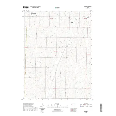
2018 Map of Bingham
USGS Topo · Published 2018About this map
Shenandoah anchors the northwest corner of this rural survey, where the edge of the city gives way to the structured agriculture of Page and Fremont Counties. The landscape is defined by the drainage basins of the W Tarkio Cr and Middle Tarkio Cr, which flow southward through a grid of section roads. Small historic hubs like Bingham and Norwich serve as landmarks in this agricultural region, while the Martin Cem provides a specific point of interest for genealogists tracing family roots in the southern portion of the quadrangle. The survey captures the modern road network, including the Anna Crose Hwy and various county routes such as Co Hwy J52, showing how these paths follow the natural contours and creek beds of Fisher Cr and Fourmile Cr.
Find a feature on this map
30 named features on this map. Tap any name to fly to it.
Don’t see what you’re looking for? This feature index may not catch every label — zoom into the map to look around manually.
Map Details
Editions of this 2018 Bingham Map
This is the sole edition of this map. No revisions or reprints were ever made.
Other maps of this area

1939 · Farragut
USGS Topo · 1:62,500

1940 · Farragut
USGS Topo · 1:62,500

1940 · Coin
USGS Topo · 1:62,500

1943 · Coin
USGS Topo · 1:62,500

1955 · Nebraska City
USGS Topo · 1:250,000

1957 · Nebraska City
USGS Topo · 1:250,000

1958 · Nebraska City
USGS Topo · 1:250,000

1978 · Shenandoah East
USGS Topo · 1:24,000

1978 · Stanton SW
USGS Topo · 1:24,000
1978 · Shenandoah West
USGS Topo · 1:24,000