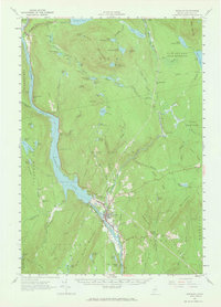
1956 Map of Bingham
USGS Topo · Published 1966About this map
Wyman Lake dominates the central river corridor of this mid-1950s survey, illustrating the industrial and natural landscape of Somerset County. The settlement of Bingham serves as a local hub near the Big Island on the Kennebec River, while the neighboring village of Moscow highlights the importance of the nearby Hydroelectric Plant. The map records a transition from river-valley habitation to the high timberlands of Moxie Mountain and Bald Mountain, with the Appalachian Trail winding through the northern ridges past Caratunk. Local social infrastructure is well-documented through landmarks like the Union Ch and Longfellow Sch, alongside smaller crossroads such as Johnson Corner. Traces of earlier transportation and industry are visible in the Old Grade and various remote outposts like Bald Mountain Sta, which once served the expansive township territories of the Maine north woods.
Find a feature on this map
96 named features on this map. Tap any name to fly to it.
Don’t see what you’re looking for? This feature index may not catch every label — zoom into the map to look around manually.
Map Details
Editions of this 1956 Bingham Map
2 editions found

Other maps of this area

1903 · Bingham
USGS Topo · 1:62,500

1904 · Anson
USGS Topo · 1:62,500

1905 · Bingham
USGS Topo · 1:62,500

1905 · The Forks
USGS Topo · 1:62,500

1907 · The Forks
USGS Topo · 1:62,500

1913 · Skowhegan
USGS Topo · 1:62,500

1925 · Pierce Pond
USGS Topo · 1:48,000

1927 · Pierce Pond
USGS Topo · 1:62,500

1928 · Dead River
USGS Topo · 1:62,500

1930 · Kingfield
USGS Topo · 1:48,000