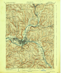
1950 Map of Binghamton
USGS Topo · Published 1950This historical map portrays the area of Binghamton in 1950, primarily covering Broome County as well as portions of Greene County, Chenango County, Cortland County, Delaware County, Onondaga County, Albany County, Saratoga County, Oneida County, Ulster County, Schoharie County, Schenectady County, Sullivan County, Madison County, Herkimer County, Otsego County, Fulton County, and Montgomery County. Featuring a scale of 1:250000, this map provides a highly detailed snapshot of the terrain, roads, buildings, counties, and historical landmarks in the Binghamton region at the time. Published in 1950, it is one of 2 known editions of this map due to revisions or reprints.
Find a feature on this map
220 named features on this map. Tap any name to fly to it.
Don’t see what you’re looking for? This feature index may not catch every label — zoom into the map to look around manually.
Map Details
Editions of this 1950 Binghamton Map
2 editions found

Historical Maps of Duane Lake Through Time
6 maps found