
Loading...
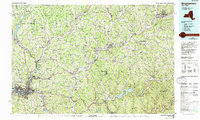
Loading map...1985 Map of Binghamton
USGS Topo · Published 1986About this map
The Susquehanna River and Chenango River converge at Binghamton, anchoring a region of the Southern Tier defined by river valleys and expanding transit corridors in the mid-1980s. This survey illustrates the urban density of Johnson City and Port Dickinson alongside the academic hubs of the State Univ of NY at Binghamton and Hartwick College in Oneonta. The landscape is a mix of protected wilderness and industrial infrastructure, where the Catskill State Park and Cannonsville Reservoir dominate the eastern reaches.
Find a feature on this map
75 named features on this map. Tap any name to fly to it.
Don’t see what you’re looking for? This feature index may not catch every label — zoom into the map to look around manually.
Map Details
Date Portrayed1985
Date Published1986
PublisherU.S. Geological Survey
Map TypeTopographic
Scale1:100,000
Physical Dimensions39.9 x 24.1 inches
Editions of this 1985 Binghamton Map
2 editions found
Historical Maps of Union Through Time
6 maps found


Featured Locations
Source Details
SourceU.S. Geological Survey
CopyrightPublic Domain