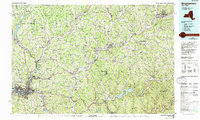
1985 Map of Binghamton
USGS Topo · Published 1993About this map
The Susquehanna River and Chenango River converge at Binghamton in this mid-1980s landscape, serving as the urban anchor for a region of deep valleys and rising plateaus. To the west, the State University of New York at Binghamton campus and the industrial corridors of Johnson City and Westover define the metropolitan core, while the eastern reaches of the map transition into the high elevations of the Catskill State Park and Walton Mountain.
Find a feature on this map
132 named features on this map. Tap any name to fly to it.
Don’t see what you’re looking for? This feature index may not catch every label — zoom into the map to look around manually.
Map Details
Editions of this 1985 Binghamton Map
2 editions found
Other maps of this area

1901 · Apalachin
USGS Topo · 1:62,500

1902 · Coventry
USGS Topo · 1:62,500

1903 · Norwich
USGS Topo · 1:62,500

1903 · Cortland
USGS Topo · 1:62,500

1903 · Harford
USGS Topo · 1:62,500

1904 · Binghamton
USGS Topo · 1:62,500

1904 · Greene
USGS Topo · 1:62,500

1904 · Oxford
USGS Topo · 1:62,500

1904 · Apalachin
USGS Topo · 1:62,500

1904 · Pitcher
USGS Topo · 1:62,500