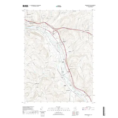
2019 Map of Binghamton East
USGS Topo · Published 2019About this map
The Susquehanna River dictates the geography of this Broome County corridor, winding southward from Binghamton through a series of riverfront settlements including Fivemile Point, Kirkwood, and Conklin. The river is punctuated by named landforms such as Collier Island, Moore Island, and Berkalew Island, which sit alongside the heavy transit infrastructure of the Norfolk Southern railway. This modern survey captures a landscape where mid-century suburban expansion meets older rural foundations, evidenced by the numerous small burial grounds like the Finch Family Cem and Levee Family Cem tucked into the hillsides away from the main valley roads. Further south, the terrain becomes more dissected by tributaries such as Little Snake Creek and Carlin Cr, where smaller communities like Conklin Forks and Corbettsville maintain their distinct identities near the Pennsylvania border marked by State Line Rd.
Find a feature on this map
122 named features on this map. Tap any name to fly to it.
Don’t see what you’re looking for? This feature index may not catch every label — zoom into the map to look around manually.
Map Details
Editions of this 2019 Binghamton East Map
This is the sole edition of this map. No revisions or reprints were ever made.
Other maps of this area

1904 · Binghamton
USGS Topo · 1:62,500

1905 · Nineveh
USGS Topo · 1:62,500

1932 · Susquehanna
USGS Topo · 1:62,500

1934 · Castle Creek
USGS Topo · 1:24,000

1935 · Binghamton West
USGS Topo · 1:24,000

1935 · Chenango Forks
USGS Topo · 1:24,000

1935 · Susquehanna
USGS Topo · 1:62,500

1937 · Binghamton East
USGS Topo · 1:24,000

1942 · Binghamton West
USGS Topo · 1:31,680

1942 · Castle Creek
USGS Topo · 1:31,680