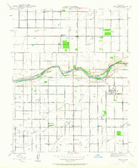
1946 Map of Biola
USGS Topo · Published 1963About this map
The San Joaquin River carves a winding path across this mid-century landscape, serving as the natural boundary between Madera County and Fresno County. This 1946 revision reveals an intensive agricultural grid defined by a network of irrigation works, including the Herndon Canal, Bullard Canal, and Empire Ditch. The settlement of Biola stands as a central hub for the surrounding farmsteads, which are punctuated by numerous rural schools such as Eastin Sch, Ripperdan Sch, and Empire Sch. Notable landmarks of the era include the Bethany Cem near the riverbanks and an Airway Beacon to the south. The transition from 1920s mapping to this post-war update illustrates the established infrastructure of the San Joaquin Valley, with named avenues like Shepherd Avenue and Olive Avenue providing a rigid framework for the region's development.
Find a feature on this map
28 named features on this map. Tap any name to fly to it.
Don’t see what you’re looking for? This feature index may not catch every label — zoom into the map to look around manually.
Map Details
Editions of this 1946 Biola Map
2 editions found
Other maps of this area

1920 · Bonita Ranch
USGS Topo · 1:31,680

1921 · Bonita Ranch
USGS Topo · 1:31,680

1922 · Gregg
USGS Topo · 1:31,680

1922 · Madera
USGS Topo · 1:31,680

1923 · Kearney Park
USGS Topo · 1:31,680

1923 · Herndon
USGS Topo · 1:31,680

1923 · Biola
USGS Topo · 1:31,680

1924 · Jamesan
USGS Topo · 1:31,680

1924 · Gravelly Ford
USGS Topo · 1:31,680
1946 · Madera
USGS Topo · 1:62,500