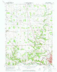
1972 Map of Bippus
USGS Topo · Published 1974About this map
The Wabash River and Little River converge in the southeastern corner of this map, framing the developing northern edge of Huntington. This 1970s record shows a landscape of agricultural drainage and early suburban growth, where long-standing rural hubs like Bippus and Goblesville are connected by a network of gridded roads such as 1000 North Road. The path of the Erie-Lackawanna railroad cuts diagonally across the townships of Warren and Clear Creek, serving as a primary corridor through the central farmland. Notable religious and community sites include the St. Felix Friary and several small country burial grounds like Maple Grove Cem. Evidence of local industry and education appears through scattered gravel pits and the presence of the Huntington North High School, reflecting a period of modernization as the county seat expanded northward.
Find a feature on this map
63 named features on this map. Tap any name to fly to it.
Don’t see what you’re looking for? This feature index may not catch every label — zoom into the map to look around manually.
Map Details
Editions of this 1972 Bippus Map
This is the sole edition of this map. No revisions or reprints were ever made.
Other maps of this area

1950 · Lagro
USGS Topo · 1:24,000

1950 · Andrews
USGS Topo · 1:24,000

1951 · Andrews
USGS Topo · 1:24,000

1951 · Lagro
USGS Topo · 1:24,000

1952 · Majenica
USGS Topo · 1:24,000

1953 · Fort Wayne
USGS Topo · 1:250,000

1953 · Muncie
USGS Topo · 1:250,000

1955 · Bippus
USGS Topo · 1:24,000

1956 · Muncie
USGS Topo · 1:250,000

1956 · Fort Wayne
USGS Topo · 1:250,000