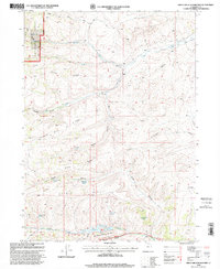
1998 Map of Birch Creek Reservoirs
USGS Topo · Published 2001About this map
Cache National Forest and the high drainage basins of Rich County define this landscape at the close of the 1990s. The map illustrates a complex network of water sources vital to this high-desert environment, including Birch Creek Reservoirs and numerous named springs such as Woodruff Spring, Beaver Pond Spring, and Putnam Spring. The terrain is marked by prominent geological features like Thousand Dollar Ridge and Strawberry Ridge, which overlook deep-cut canyons and seasonal watercourses.
Find a feature on this map
32 named features on this map. Tap any name to fly to it.
Don’t see what you’re looking for? This feature index may not catch every label — zoom into the map to look around manually.
Map Details
Editions of this 1998 Birch Creek Reservoirs Map
This is the sole edition of this map. No revisions or reprints were ever made.
Other maps of this area

1912 · Randolph
USGS Topo · 1:125,000

1954 · Ogden
USGS Topo · 1:250,000

1958 · Ogden
USGS Topo · 1:250,000

1960 · Ogden
USGS Topo · 1:250,000

1968 · Dairy Ridge
USGS Topo · 1:24,000

1968 · Randolph
USGS Topo · 1:24,000

1968 · Woodruff
USGS Topo · 1:24,000

1968 · Meachum Ridge
USGS Topo · 1:24,000
1968 · Neponset Reservoir NW
USGS Topo · 1:24,000
1969 · Birch Creek Reservoirs
USGS Topo · 1:24,000