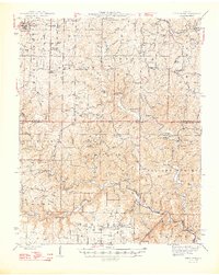
1948 Map of Birch Tree
USGS Topo · Published 1948About this map
The Eleven Point River carves a deep path through the southern half of this mid-century survey, a landscape defined by sharp ridges and a complex system of ponds and springs. The northern territory around Birch Tree is anchored by the St Louis - San Francisco RR and several family-centric landmarks, including Oak Forest Cem and Warm Corners Cem. The central portion of the map is dominated by the State Eleven Point Game Refuge, where topographic features like Possum Trot Lookout and Tram Lookout provided essential fire observation points for the forested Ozark terrain. Local industry and subsistence are evidenced by Turners Mill and the Fish Hatchery near Greer Spr. The prevalence of small rural schools such as Banner Sch and Sunnyside Sch reveals a dispersed but active settlement pattern across the township boundaries of Bartlett and Winona during the late 1940s.
Find a feature on this map
116 named features on this map. Tap any name to fly to it.
Don’t see what you’re looking for? This feature index may not catch every label — zoom into the map to look around manually.
Map Details
Editions of this 1948 Birch Tree Map
2 editions found

Other maps of this area

1915 · Eminence
USGS Topo · 1:62,500

1917 · Eminence
USGS Topo · 1:62,500

1928 · Cardareva
USGS Topo · 1:62,500

1931 · Bandyville
USGS Topo · 1:48,000

1941 · Gatewood
USGS Topo · 1:62,500

1943 · Thayer
USGS Topo · 1:62,500

1944 · Van Buren
USGS Topo · 1:62,500

1944 · Couch
USGS Topo · 1:62,500

1944 · Birch Tree
USGS Topo · 1:62,500

1945 · Gatewood
USGS Topo · 1:62,500